
Stalham is a hidden gem with far more than meets the eye. In his latest column, Robert Paul, Museum of the Broads director and president (and past chairman and vice president of the Broads Society) delves into the town's past, present and future.
We are all in a hurry these days and rarely have time to stop and appreciate what is around us.

Bypasses are often constructed to divert traffic away from the centres of our towns and villages – a good thing of course, relieving congestion and pollution. The downside is that people rush through perhaps only visiting the supermarkets and retail parks that have often been built on the outskirts.
When we do have time to stop and explore, there are often surprises in store, interesting buildings, fascinating histories and little gems to discover.
Nowhere is this more true than at the town of Stalham on the southern most ‘borders’ of North Norfolk.
, which is now part of the Museum of the Broads.")
It has always been a town of two halves, being separated at first by the Yarmouth and North Norfolk Light Railway.
This was later the Midland and Great Northern Railway (the M&GN Line) often referred to as the ‘Muddle and Get Nowhere’ line owing to its mostly rural destinations. At its peak there were 100 trains per day.
This nickname became the ‘Missed and Greatly Needed’ following closure on February 28, 1959. The present A149 now follows the route of the old railway continuing to ‘divide’ the town.

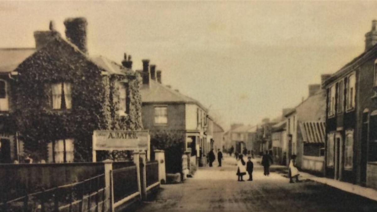
But back to the early days. There are several explanations of the derivation of the name of Stalham the most widely held view is that it means ‘settlement by the river’ chosen as a good location because of it’s accessibility by water, the abundance of timber for fuel and construction, good farmland and a slightly raised, dry site where the present High Street now exists.
Flat-bottomed sailing craft made their way up the River Ant searching for such a place. The first recording of Stalham was in 1045 in a document called the Codex Diplodmaticus Aevi Saxonici.
 in the background, in May, 1934. Burton's mill to the left.")
The Abby of St Benet's at Holme held 120 acres of rich farmland at Stalham, supplying produce to the abbey by wherry.
So the future of the town was secured due to the efficient transport system provided by the river, the richness of the farmland, and the availability of timber and other natural resources.
The remains of St Benet’s Abbey are still in evidence on the banks of the River Bure close to Ludham.

Moving on a few centuries, the splendid St Mary’s Church, completed in 1400, dominates the High Street and remains the oldest building, with it’s perpendicular-style and distinctive squat tower.
Extensive re-building took place in the town in the 1690s replacing the easily sourced reed for thatching and timber for construction, with soft red brick and tiles, made in the local brickworks.

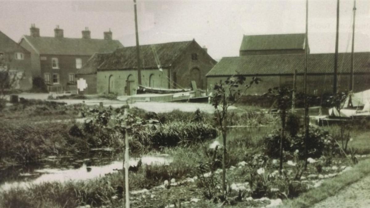
The river to the staithe became known as Stalham Dyke, the mills and granaries were extending and developing apace, thanks largely to the waterborne transport system.
Here, Burton was a name that has been associated with mills and granaries at Stalham for more than two centuries and the family continued in business up to very recently (around 1995) I remember buying dog food or flour at the mill, and waiting for my receipt, written by fountain pen at a Dickensian style desk in a little office that had changed little for a century.
Mills, granaries and farming were the life blood of the town – the 17th century Jacobean manor house, Stalham Hall on the old Yarmouth Road was one of the biggest landowners.
The 19th century saw major developments in Stalham’s growth – it remained largely self- sufficient, exporting grain and livestock by river and wagon to Norwich.
The year 1833 saw the founding of the town fire brigade, one of the oldest in the country.
The building and fire pump still exists and is managed by the Firehouse Museum Trust. It was established due to unreliable insurance and maybe the high fire risk posed by mills.
There are records of major fires in mills around Norfolk and the Broads, and Bristow's Mill in the town was actually destroyed by fire in 1908. Interestingly, I have since discovered to be distantly related to the Bristows.
Back to the High Street and the Barclays Bank building. While space doesn’t allow the full story, a little to whet your appetite.
It started out as a private credit union, but in 1891, architects Boardman & Sons of Norwich and ‘How Hill’ fame, designed a new building for the Gurneys who later amalgamated with Barclays to become Barclay & Company.
In 1906 it was destroyed by fire, was restored and reopened in 1908, continuing as a bank until 2015 when it closed for the final time.
Big changes occurred in the late 19th century with a ‘board school’ opening in 1878 and of course, the coming of the railway, reaching Stalham in 1881 from Melton Constable.
This transformed everything including the demise of river transport and wherries. Once the Broads had been discovered by authors such as George Christopher Davies and Peter Henry Emmerson, it set the scene for the huge growth of the area as a holiday destination, with one of the largest boat hire companies established close to the staithe.
With the railway line closing in1959, the A149 became the main road transport connection, dividing the town once again.
So what of the present day? After a somewhat troubled period following the building of a major supermarket close to the High Street in the 1990s which saw the demise of a number of shops, Stalham is once more on the up and up.
The High Street is once more flourishing with many shops, small businesses and cafés all doing a roaring trade. There are two pubs and two museums – the Firehouse Museum and of course ‘my own’ Museum of the Broads down on the staithe.
In 1841, the population was 761 and today stands at just under 4,000.
Thanks to the tireless work of the Stalham Area Business Forum, town council and local businesses, a new iconic town sign has been erected and now stands at the top of the High Street.
Well worth a visit in itself, it depicts elements of the Town’s history with beautifully crafted ‘images’ by local craftsmen and women, featuring a windmill, the railway station, the Firehouse Museum, St Mary’s Church, the Barclays building, and the magnificent Baptist church.
Its message is ‘Stalham Welcomes You’ so next time when on the A149, don’t rush past, but stop and enjoy a little of what the town has to offer.
What would I like next for Stalham? Well, as mentioned more than once here, the town is a town of two halves.
I would like the major businesses such as the well known supermarket and the various national housing development companies, much in evidence right now, to unite with the town council and design and build an iconic pedestrian and cycle bridge linking the staithe and the town.
It could be fabulous – I can’t wait.


Comments: Our rules
We want our comments to be a lively and valuable part of our community - a place where readers can debate and engage with the most important local issues. The ability to comment on our stories is a privilege, not a right, however, and that privilege may be withdrawn if it is abused or misused.
Please report any comments that break our rules.
Read the rules here